Picture a plane flying through thick Himalayan fog. The pilot can’t see the mountain ahead. Suddenly, the aircraft changes course on its own, and disaster is avoided.
That’s no longer just a hopeful scenario. This new Nepali scientist aircraft technology can now do exactly that, automatically. Researchers at Tribhuvan University have developed a system that redirects aircraft to safety when fog or clouds hide the mountains ahead.
This breakthrough targets one of Nepal’s deadliest aviation problems directly. It’s called CFIT, or Controlled Flight Into Terrain, and it has claimed lives for decades. Now, a homegrown Nepali innovation is offering a real solution.
In this article, we’ll explain how this Nepali scientist aircraft technology works, who built it, and why it could reshape aviation safety across Nepal’s mountains.
Why Nepal Needed This Technology So Badly
Nepal’s mountainous terrain makes flying uniquely dangerous. Sudden fog, unpredictable winds, and towering peaks combine to create conditions few countries face at this scale.
According to data from the Civil Aviation Authority of Nepal’s Safety Management Department, cited by Techpana, 13 out of 24 aircraft accidents recorded between 2013 and 2022 were caused specifically by CFIT. That’s more than half of all recorded accidents in that decade.
CFIT occurs when an aircraft, still fully under pilot or system control, unexpectedly crashes into terrain, a mountain, or another obstacle. Crucially, the pilot often has no warning that danger is near. Visibility loss from fog or cloud cover is usually the root cause, leaving pilots flying blind toward hazards they simply can’t see.
This is precisely the problem Tribhuvan University’s research team set out to solve.
Who Built This Nepali Scientist Aircraft Technology
The research was conducted by the Institute of Engineering at Tribhuvan University, with direct funding from the United States Air Force, according to Techpana’s reporting.
Dr. Sudip Bhattarai led the project as principal investigator. His co-researchers included Maheshchandra Luintel and Surya Prasad Adhikari, supported by a broader research team of Kamal Darlami, Ayush Bhattarai, Pratibha Bhandari, Nabin Bhandari, and Nishchal Paudel.
Dr. Bhattarai’s academic background aligns closely with this work. According to his research profile, his expertise spans experimental and computational aerodynamics, along with aircraft performance and operations. This research direction connects to peer-reviewed work published in the Journal of Aircraft, which similarly documents testing of an “in situ flight path generation technique” specifically designed to mitigate CFIT risk in Nepal’s mountainous flying environment.
The project began in May 2023 and ran for approximately one and a half years. According to Dr. Bhattarai, the team’s central goal was clear from the outset. They wanted to completely prevent CFIT accidents in Nepal, specifically addressing how an aircraft can stay safe even when fog or clouds block forward visibility entirely.
How the Technology Actually Works

The system is called In Situ Path Generation, meaning it generates new flight paths in real time, during the flight itself.
According to Techpana’s detailed explanation, the technology gives the aircraft a form of autonomy. When a pilot or remote operator loses control accuracy near a hazard, the system can independently reroute the aircraft toward safety.
Here’s the mechanism. While flying, the system continuously compares the terrain directly around the aircraft against a Digital Elevation Model, or DEM. A DEM is essentially a three-dimensional computer map showing exact ground elevation, capturing mountains, valleys, flatlands, and riverbanks in precise detail.
If this real-time comparison detects that the aircraft is approaching a mountain or obstacle, the system generates 80 new safe waypoints within just three seconds. It then guides the aircraft directly toward one of these newly identified safe points.
The Decision Logic Behind Every Reroute
What makes this system particularly sophisticated is that it doesn’t follow one fixed escape maneuver. Instead, it evaluates the safest available option based on the specific situation.
The system follows a clear decision hierarchy. First, if continuing straight ahead at the current altitude avoids danger, the aircraft simply continues forward. Second, if the straight path looks risky, the aircraft weaves side to side while maintaining its current altitude to stay clear of the hazard.
Third, if weaving alone can’t avoid the danger, the system increases altitude to fly safely over the obstacle. Fourth, if none of these options work, the aircraft climbs while simultaneously turning away from the threat.
If the system still can’t identify an immediate safe path forward, it enters what’s called loiter mode. The aircraft circles within a defined safe area, continuously searching for a viable route, until one becomes available. Finally, if no safe path can be found at all, or if the intended destination route remains blocked, the aircraft returns to its original starting point.
This layered, adaptive approach means the system always chooses the least disruptive safe option first, only escalating to more dramatic maneuvers when genuinely necessary.
Testing the System in Mustang
Theory is one thing. Real-world testing is another, and this team put their system through genuinely demanding conditions.
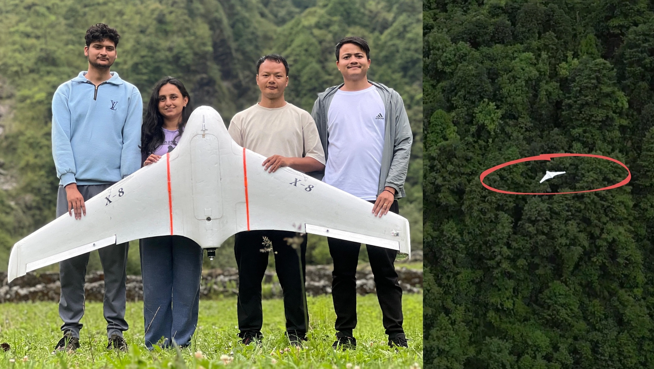
The researchers used a Skywalker X8 unmanned aerial vehicle for testing, equipped with a Pixhawk 6C flight controller and PX4 autopilot firmware. This hardware combination enabled the in situ path generation system to function during actual flight.
Testing took place in Lete, a village in Mustang district known for its dramatic mountain terrain. During flights, the team deliberately maintained distances of less than 100 meters from surrounding terrain. In some test runs, they intentionally flew the UAV within 50 to 100 meters of steep cliffs and elevated terrain, essentially inviting the exact crash scenario the system was designed to prevent.
Dr. Bhattarai described the test directly. His team deliberately aimed the UAV on a trajectory meant to collide with a mountain. The onboard controller then recognized the danger, altered the aircraft’s predetermined path, and safely redirected it. Using this system, the team successfully guided the UAV more than 10 kilometers to safety within just 30 minutes.
How This Compares to US Research on the Same Problem
Interestingly, Nepal isn’t the only country tackling CFIT through advanced technology, though the approach here differs meaningfully from American research.
According to Dr. Bhattarai, the United States has also researched CFIT solutions extensively. American research has successfully developed a technique called rapid climbing, where an aircraft facing imminent collision simply ascends sharply and directly. However, this approach hasn’t yet been fully implemented in practice, according to Dr. Bhattarai’s discussions with the US Air Force.
He also highlighted the difference in stakes between the two countries. CFIT causes billions of dollars in losses annually in the United States. In Nepal, however, the cost isn’t purely financial. Many lives have been lost to these accidents.
Given this human toll, and Nepal’s unique mountainous flying conditions, the research team deliberately built a system distinct from the American approach, one specifically designed with manned aircraft safety as the core priority.
Where This Technology Could Be Used First
While the ultimate ambition includes commercial aircraft, near-term adoption looks more realistic for drones.
According to Dr. Bhattarai, the research team already discussed this technology with stakeholders across Nepal’s aviation sector, including the Civil Aviation Authority of Nepal, known as CAAN. These discussions revealed real technical and regulatory challenges standing in the way of immediately installing the system on manned passenger aircraft.
However, Dr. Bhattarai emphasized that the technology holds significant value for companies pursuing commercial drone operations. Nepal genuinely needs reliable drones for delivery services, remote sensing, and disaster search and rescue missions. Yet, the country’s challenging geography consistently disrupts commercial drone flights.
Long-distance manual drone flight simply isn’t practical in Nepal’s terrain, according to Dr. Bhattarai. Mountain valleys and unpredictable weather make it extremely difficult for a remote pilot to maintain accurate control from a distance. This challenge intensifies further for Beyond Visual Line of Sight flights, where operators can’t see the drone directly at all.
Dr. Bhattarai offered a vivid example. Flying a drone manually from Pokhara to Mustang would mean navigating mountains and sudden winds along the entire route. Under manual control alone, the chances of completing that journey without an accident remain very low.
The Technology’s Current Capability Level
According to Dr. Bhattarai, the system currently operates between Autonomy Level 3 and Level 4, a meaningful milestone in aviation automation terms, though not yet fully autonomous.
This level of autonomy means the aircraft can independently identify obstacles along its path and determine a safe route during genuinely risky situations, without requiring constant human intervention. Dr. Bhattarai expressed confidence that if Nepal’s aviation industry adopts this technology, commercial drone usage across the country could expand meaningfully.
Why This Breakthrough Matters Beyond Nepal
This Nepali scientist aircraft technology carries significance that extends well past domestic aviation safety.
First, it directly addresses a problem with genuinely global relevance. Mountainous, weather-unpredictable regions worldwide face similar CFIT risks, meaning successful Nepali research here could eventually inform aviation safety practices elsewhere.
Second, it demonstrates Nepal’s growing capacity for original scientific research, backed by international partners like the US Air Force. This kind of applied, internationally funded research signals Nepal’s aviation and engineering institutions can produce genuinely innovative, field-tested solutions.
Third, the technology’s near-term drone applications align closely with Nepal’s practical development needs. Reliable, safe drone operations could meaningfully improve disaster response, remote healthcare delivery, and infrastructure monitoring across Nepal’s most geographically isolated communities.
What Still Needs to Happen Next
Despite this genuine breakthrough, real-world deployment on passenger aircraft remains a longer-term goal, not an immediate reality.
Regulatory frameworks will need to evolve significantly before manned aircraft can carry systems like this. CAAN and industry stakeholders will need to work through certification standards, safety validation processes, and integration requirements before broader adoption becomes feasible.
For commercial drone operators, however, the path forward looks considerably shorter. Companies already exploring delivery, remote sensing, or search and rescue drone operations in Nepal could potentially integrate this technology much sooner, given it has already been successfully tested in genuinely challenging mountain conditions.
Conclusion
This Nepali scientist aircraft technology represents a genuinely significant step forward for aviation safety in one of the world’s most challenging flying environments. Built by Dr. Sudip Bhattarai’s team at Tribhuvan University, with direct support from the US Air Force, the In Situ Path Generation system tackles CFIT accidents head-on, using real-time terrain comparison and autonomous rerouting.
Successful testing in Mustang’s demanding mountain terrain proved the concept works, guiding a UAV safely away from deliberately dangerous flight paths. While manned aircraft adoption will take time, given real regulatory and technical hurdles, commercial drone applications look genuinely promising much sooner.
Ultimately, this breakthrough shows what’s possible when Nepali researchers apply world-class engineering directly to the Himalayas’ most dangerous flying conditions. As fog and mountains continue posing risks across Nepali skies, this homegrown technology offers real hope for a safer path forward.
FAQ: Nepali Scientist Aircraft Technology for Fog Safety
What does this new Nepali scientist aircraft technology actually do?
It automatically redirects aircraft, especially drones, to a safe flight path when fog or clouds hide mountains, preventing collisions with terrain.
Who developed this technology?
Dr. Sudip Bhattarai led the research team at Tribhuvan University’s Institute of Engineering, with funding from the United States Air Force.
What is CFIT, and why does it matter for Nepal?
CFIT stands for Controlled Flight Into Terrain. It caused 13 of 24 recorded aircraft accidents in Nepal between 2013 and 2022.
How does the technology detect danger during flight?
It compares the aircraft’s surrounding terrain in real time against a Digital Elevation Model, generating new safe waypoints within three seconds if risk is detected.
Where was this technology tested?
The system was tested using a Skywalker X8 drone in Lete, Mustang district, flying within 50 to 100 meters of steep mountain terrain.
Can this technology be used on passenger planes yet?
Not immediately. Technical and regulatory challenges remain for manned aircraft, though commercial drone applications look feasible much sooner.